![99745fd6-afc8-495e-a1a1-c5fa6c1501aa.png]](https://resources.spectotechnology.com/hs-fs/hubfs/99745fd6-afc8-495e-a1a1-c5fa6c1501aa.png?width=300&height=113&name=99745fd6-afc8-495e-a1a1-c5fa6c1501aa.png)
If the total station is moved, a full resection will be required to re-establish its position for accurate measurements.
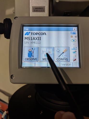
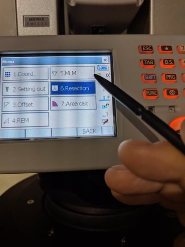
The first thing to do is to resection the total station manually with the coordinates of two prisms from GeoX. We will use the MSAXII menus to perform a resection, the resection wizard will take use through each step and make it relatively easy. This will involve us measuring two known points, entering their coordinates, and then using those to calculate the current position of the AMTS.
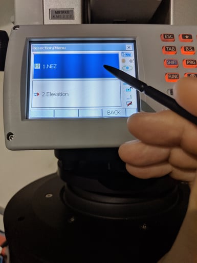
- Enter two of the prism’s coordinates from GeoExplorer as known point 1 and known point 2.

- Click Next and enter the coordinates for each prism. Then click OK and measure each.
- Click 'Yes' for each prism and 'Yes' to calculate. The AMTS will tell you it's new coordinate.
Create a New Reference point from a live control at a known point, allowing us to run an initial calibration, similar to setting up a new AMTS.
- Take live control.
- Aim the AMTS at the known prism, give this a new name, but similar, so you know which point it is a duplicate.
- Add from pointing, measure, and save.
Update the station coordinates in GeoX. Enter this as the coordinate of the amts in GeoExplorer, the same way you did when first setting up.
- Click on AMTS settings>
- Calibration>
- Fixed Position
- Then enter the northing, easting, and height you just calculated from Known 1 and Known 2 during resection

- Save, and open calibrations > Preview > Add single
- Under control observations, remove all but one of your original references, the one you want to use for this cal. Add a point and choose your New Reference. Add the original coordinates to the manual coordinates of the new point.

- Now remove the original reference, leaving only the New Reference. Click preview. It should be valid.
Now we need to export a coordinate file for all the points.(this only needs to be done once to create a master file of all coordinates on the AMTS)(if you are setting out a new AMTS with Grid coordinates skip step one)
- Click on the exports.

- Open the file and reformat to Name, Northing, Easting, Elevation. It should look like the below(if you have Grid coordinates from a manual survey, your file will look different but format it as shown below)

- Rename the points in column one with a new name so you can add them as new points.
- Now we need to reimport these points
- Go to live control > add Observations > select the last option "Add multiple from coordinates csv file", choose your file.
- Now read all the points, including references. And update the calibration to use more of the new points as you normally would.