Manually Calculate Coordinate from RAW ATS Readings (ARTICLE)
Manually calculating coordinates from raw Automated Total Station (ATS) readings involves converting angular measurements and slope distances into precise 3D coordinates. Here’s a step-by-step guide to assist you:

ATS instruments provide:
- Horizontal Angle (Hz): Angle relative to a reference direction (e.g., North).
- Vertical Angle (V): Angle relative to the horizontal plane.
- Slope Distance (SD): Direct line distance between the instrument and the target point.
When working with raw Angular and Slope Distance (SD) data collected from an Automated Total Station (ATS), you can calculate elevation differences, easting, and northing manually using trigonometric relationships. Below are the steps and formulas for reference:
1. Calculating the Difference in Elevation (dEl)
To determine the elevation change between two points:
-
- Key Variables:
- SD: Slope Distance (measured distance along the line of sight).
- Theta (θ): Vertical angle from the horizontal plane.
- Formula:
- Horizontal Distance (HD) = SD × cos(θ)
- Difference in Elevation (dEl) = SD × sin(θ)
- Key Variables:
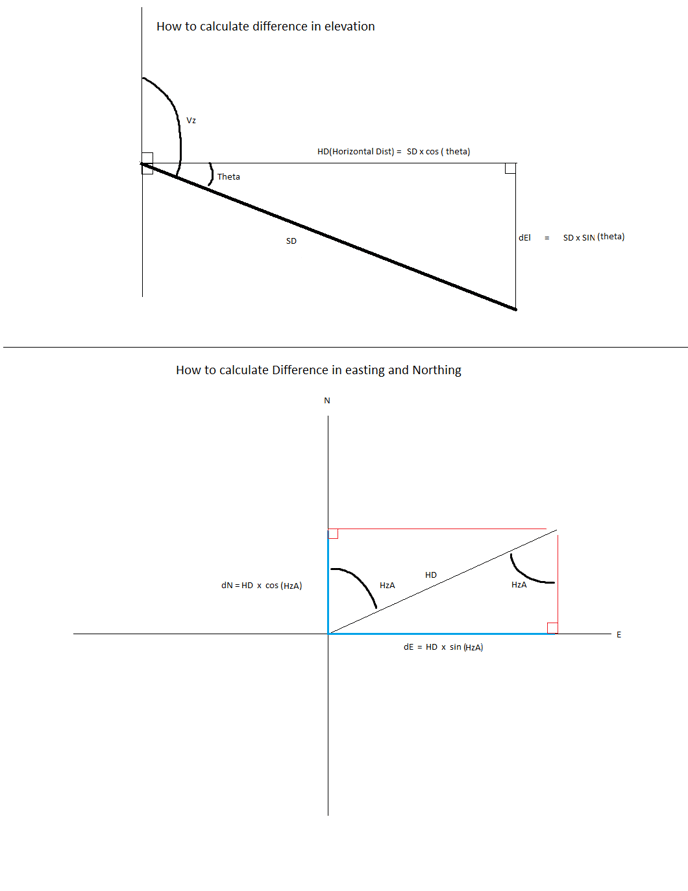
The diagram above shows the trigonometric relationships. The elevation difference is derived from the vertical component of the slope distance using the sine of the vertical angle.
2. Calculating Differences in Northing (dN) and Easting (dE)
To compute changes in coordinates along the North and East axes:
-
- Key Variables:
- HD: Horizontal Distance, calculated using SD × cos(θ).
- HzA: Horizontal angle from the reference North direction.
- Formulas:
- Difference in Northing (dN) = HD × cos(HzA)
- Difference in Easting (dE) = HD × sin(HzA)
The graph illustrates the breakdown of HD into its Northing and Easting components. Using the horizontal angle (HzA), the HD is projected into the two axes:
- dN represents the change in the north-south direction.
- dE represents the change in the east-west direction.
Practical Application
- Start with your ATS readings: Slope Distance (SD), Vertical Angle (Theta), and Horizontal Angle (HzA).
- Calculate the Horizontal Distance (HD) using SD and Theta.
- Use the HD and HzA to compute changes in Northing and Easting.
- Combine these calculations with your reference coordinates to determine the new point location.
- Target Northing = AMTS Northing + dN
- Target Easting = AMTS Easting + dE
- Target Elevation = AMTS Elevation + dEl
These manual calculations are essential when automated software is unavailable or when validating survey results for accuracy.
![99745fd6-afc8-495e-a1a1-c5fa6c1501aa.png]](https://resources.spectotechnology.com/hs-fs/hubfs/99745fd6-afc8-495e-a1a1-c5fa6c1501aa.png?width=300&height=113&name=99745fd6-afc8-495e-a1a1-c5fa6c1501aa.png)